Posts Tagged With: map

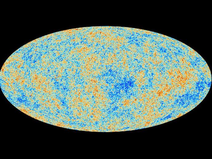
A map which tells the age, origins, and ingredients of our universe – from The Planck Mission

Isn’t that one interesting map – never seen anything like that before – and those dots of blues and yellows reveal so much!
Basically, the mottling in the map represents small changes in the CMB background, which permeates the universe. The cool part is, these deviations are essentially the “seeds” of the stars, galaxies, and clusters we see today – the “seeds” of matter.
I guess the density differences amplified with time – but that’s just me making sense of it…
And the pattern: the age, shape and contents of the universe.
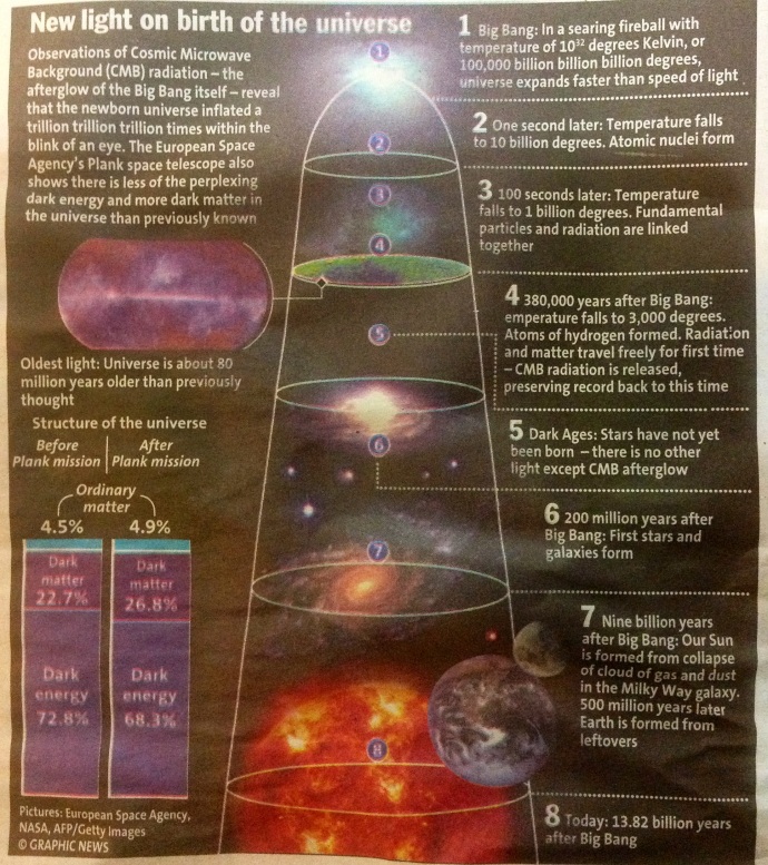
But if you still can’t decipher the map (like myself), check out the picture below. Took this snapshot from the newspaper I was just reading – and I think it’s a wonderful summary of the breakthroughs of the Planck Mission, and also of the timeline of our expanding universe.

Source: The STAR, TUESDAY 26 MARCH 2013, Malaysia

Source: The STAR, TUESDAY 26 MARCH 2013, Malaysia

Though I must add, the Planck Mission (by NASA/ESA) has also proved that temperature differences in the opposite hemispheres of the sky (it’s the first I’m hearing the universe has hemispheres – must read up a bit about this!) are not anomalies of measurement (as they were once thought of), but the real deal…and there’s something about a “cold spot” as well: it’s now proven to be bigger than predicted.
Cool stuff right.

Here’s some links if you’ll like to find out a bit more:

Planck Mission Brings Universe Into Sharp Focus

New View of Primordial Universe Confirms Sudden “Inflation” after Big Bang

The first link is NASA’s article, and has much more detail. The second is by Scientific American, easier to digest 😉

ps. The CMB (cosmic microwave background) is essentially light, the earliest light in our universe, produced when the first elements, Hydrogen and Helium were formed. This was 380 000 years after the formation of our universe. But as the universe expanded, the wavelength of these light waves lengthened, and now it is of the microwave radiation wavelength – wonder if it will ever become radio waves!

Categories: Misc, Physics, The Universe | Tags: , , , , , , , , , , | 4 Comments

A Brief Observing Guide for Asteroid DA14

The best pic I’ve seen thus far, for catching asteroid DA14.
All times are in GMT, on Feb the 15th. The asteroid begins from the bottom of Leo and moves to the Plough.

You’d need a pair binoculars (50mm aperture is the minimum, I believe) to see it. It’s too faint for the naked eye, about 250 times fainter than the stars of Ursa Major (the Plough). If you’ve got a telescope, all the better!

Sadly, I can’t be catching it today…Ohh why (said in anguish!)
The clouds are too heavy down here. I can’t see a single star – so there’s no way I could navigate the constellations.

And if you’re from the Americas, you won’t be able to catch it too, as its daytime. But, if you’re at the Eastern Hemisphere, keep a lookout.

This is the view from home. Not the best pic, but the skies are entirely void of stars today – and it’s all just an orange blur (though the sky looks black in the pic).
Oh well…

…guess I’ve gotta wait  40 more years before I see you. Till 2046 then!20130216-021604.jpg

Good luck hunting guys!

And yes, don’t forget to check out these links:
1. How to spot Asteroid 2012 DA14 – by The Guardian
2. NASA’s Guide

My bed’s calling 😉

Categories: Amateur Astronomy, Misc, Observation Tips | Tags: , , , , , , , , , | Leave a comment

StarHopping – Old Skool Style

So, if you don’t have a PushTo, GoTo or a Telrad (like myself), this is whatcha gonna need for some old-skool style star-hopping.

Gear

Star Chart

Here’s a link to a free downloadable version which I’ve used for my observation nights with my club: SFA Star Chart. Star Charts map constellations, nebulae and galaxies, and they sometimes even indicate brightness! So, before you start observing, you’ll need a star chart to know what’s up in the sky tonight, decide which object to hunt for and use the pattern of stars to guide you there. Without star-hopping, locating an object is like looking for a needle in a haystack – especially if your eyepiece has a narrow field of view and a short focal length – talk about tunnel vision!

Hands

A Compass

Instructions

The trick is to imagine your star chart as a sphere encapsulating Earth.

From the Equatorial Region

Check your Star Chart and lookout for today’s date (its on the horizontal axis). If you imagine a vertical line through the point which marks the date, that would be the view of the skies at the Celestial Meridien at 8 pm. Then on, just minus or add the time of your viewing to the Meridien (at 8 pm) and shift your focus (the imaginary vertical line) on the map – basically, aligning the Celestial Meridien to the current time. So, if you’re observing at 11pm, you would need to add 3 hours (11-8=3) to the 8pm Meridien, which means, looking 3 hours to the left of the imaginary 8pm Meridien line on the map. if you’re observing at say 7 pm, look an hour (8-7=1) to the right of the 8pm Meridien. Once you’ve approximated your vertical axis, look up to the skies and align it with what you see.

Now if you wanna see the Eastern sky, align yourself to face East – here’s where the compass comes in. Look at the left of the vertical line which matches your time of viewing and date. And if you want to see the Western sky, face West and look at the right of the imaginary line. You see, as Earth rotates, you’ll see new stars emerging on your East and other stars falling under the Western horizon.

It all may sound quite confusing. So, back to basics, imagine your chart as a sphere wrapped around Earth, and remember how Earth’s rotation makes the sky look like its moving. Check out: Why Stars Move

Next up, is using your hands. Once, you’ve located what you see on the chart, to hop to the right star, you’ll need to measure. On the chart, are “latitude lines” 10 degrees apart. How on earth would you know what’s 10 degrees apart in the sky. Well, make a fist and point it up to the sky, the length of a fist measures 10 degrees in the sky. The thumb, about 5 degrees. And if you open you hand as wide as possible, from the tip of the little finger to the thumb’s tip, 25 degrees.

Now, you’re all set!

Zoomed in Star Chart

ps. What’s the Celestial Meridien?It’s a circle the passes through the north and south celestial poles, the zenith and nadir. Read: Measuring the Sky to find out more.

Categories: Amateur Astronomy, Observation Gear, Observation Tips, Stars | Tags: , , , , , , , , | 6 Comments

SkEye Planetarium App

My favourite planetarium App for Android mobiles: SkEye!

Why I absolutely love this app you ask?

1.  It’s calibrates to the section of the sky you’re pointing almost instantly. I have the GoSkyWatch app too but it’s does not calibrate as fast as SkEye when you’re moving your mobile and pointing it to different parts of the sky.

2. It has a search function that guides you (with a bullseye reticle) to point your mobile and zoom in onto the interstellar object you’re looking for.

3. Plus, it has a huge database of deep sky objects, Messiers and NGCs. Way more than I could ever hope to observe from the suburbs with moderate light pollution levels, in which I live in, through my 10″ scope.

4. It can be used as a PUSHTO Guide on your telescope optical tube assembly. All you’ve got to do is attach your mobile to your scope, align the app’s map to what you’re observing and voila, you now have your very own tracking system!

5. All these features come free!

For detailed instructions, visit: SkEye, Planetarium and PUSHTO Guide for Android.
Visit the SkEye’s official site at:  http://lavadip.com/skeye/index.html

Categories: Amateur Astronomy, Observation Gear, Observation Tips | Tags: , , , , , , , , , , | 2 Comments

Create a free website or blog at WordPress.com.